Crowned with the Triple Crown at 67
For most people, 2,000+ miles sounds like the road trip of a lifetime. But for those bitten by the long-distance hiking bug, it sounds like their next adventure. The Triple Crown of hiking is made up of three long-distance trails in the US running South to North: one on the west coast (The Pacific Crest Trail), one in the Rockies (The Continental Divide Trail) and one on the east coast (The Appalachian Trail).

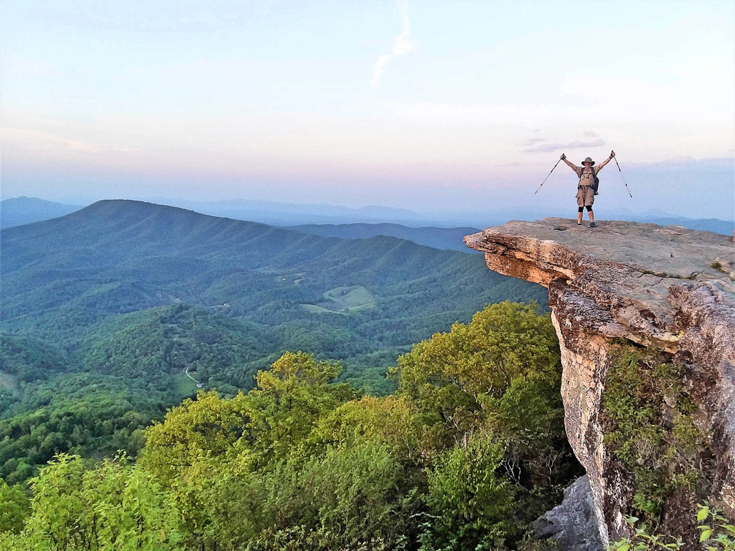
McAfee Knob, Appalachian Trail, Virginia
When I first heard that my friend, Chuck Shugart, was hiking from the Mexico border to the Canadian border on the Pacific Crest Trail, I thought he was crazy. How could someone walk that far? I love hiking, but I didn’t understand the draw of spending months on end walking. But, after hearing the passion in his voice as he talked about his adventures on the PCT, I started to understand the draw. I looked forward to hearing more about his adventures as he completed the Continental Divide Trail (CDT) and Appalachian Trail (AT). After completing the Triple Crown at 67, I caught up with Chuck to learn a little more about his time on the trails.
One of the things I like about long-distance hiking is that you get more than just a taste of living outside. More than a day hike or a brief overnighter. Even more than a week-long Boy Scout 50 miler - not that there's anything wrong with those experiences. They are just different ways to enjoy the outdoors. But when you live for months on the trail, it has a chance to really become a part of you...or maybe you become a part of it. Whatever it is, I like how that feels. I think maybe too, that it is the challenge of finding out whether I am equal to that challenge. The trail takes the measure of a man. And I don’t think there is any other way to find out those certain things about yourself that are revealed as you face the adversity, as well as drink in the awesome beauty of these wild places.

What was the order you hiked each trail? Looking back, would you have done them in a different order?
I hiked the PCT first. CDT second. AT last. That is my recommendation for the best way to do it. I didn’t know it at the time, but looking back it was perfect. Overall, in my opinion, the PCT is the best built (tread, grade, route, pretty well marked when I did it) and most scenic of all three. It will easily draw you into liking thru-hiking. Trail support and access to resupply are adequate for a first time thru-hike. The PCT is not as well established as the trail community and support along the AT, but it is good enough. The CDT as a second step is good because it adds route-finding and resupply challenges that aren’t insurmountable but push you to sharpen your wilderness skills started on the PCT. The AT, although the best marked and best supported, shortest and lowest, is in my opinion, the most physically challenging of all three. Trail tread at times is almost nonexistent and even more challenging than almost anywhere on the CDT. And steep, I don’t think they had invented switchbacks yet when they built the AT: straight up and straight down. It’s no wonder that a lot of places on that trail are walking up or down dry (or water flowing) creek beds and washes. Roots and rocks.

Mt. Rainier, Pacific Crest Trail, Washington
Do you have any standout stories from the trails?
So first a scary story. I was coming down from Mount San Jacinto and Fuller Ridge in Southern California (not too far from Palm Springs). It was HOT! 103 degrees F. There wasn’t much water on the descent and 3 or 4 miles to go to the next known water source. I came upon a small stagnant pool of murky water in the shade of a big boulder (Volkswagen size boulder). The little pool was about 6 feet across. I didn’t want to get water to drink there. But I figured I could cool myself down by splashing some water on my face. So I knelt down and scooped a little water in my hands and rubbed it on my face and neck. It was warmish but felt good. So I decided that I could just splash it all over me and get everything wet and it would help me stay a bit cooler for a while. So I splashed it more vigorously when from behind a basketball-sized rock on the other side of the puddle I heard that familiar buzz of a rattlesnake. He immediately took off in the opposite direction, but I shot backward so fast I ended up on my fanny about 6 feet back from the puddle. It was a rookie mistake. I should have been more careful about checking the area out before I got on my knees that close to rocks I couldn’t see behind or under.
Next, a funny story. After hiking a long time, your appetite gets pretty strong. There were several (7 or 8) of us at a resort only about 80 miles from the end of the PCT in Northern Washington called Stehekin. We were all pretty happy that the finish line was near. We decided to enjoy a nice last meal together at the small café at the resort. We ordered all the racks of ribs they had left, salads, fries, desserts and a few other things. We ate and ate. We didn’t send so much as a French fry back to the kitchen. When the waitress came out to clear the table, her eyes went wide and she exclaimed, “I’ve never seen so many skinny people eat so much food.” We upheld the reputation of thru-hikers to be notorious eaters when they’re in town.
Now, a notable character. Some thru-hikers really enjoy walking long distances each day. I lean that way myself. I am the happiest when at the end of the day, I check the map and find I’ve hiked 30 miles that day; or even better, several days in a row. One such fellow was Miles. We hiked together for a week or so on the AT. He ended up finishing the whole thing in 96 days. When I went back to finish the AT in the Spring of 2019, I had 108 miles left, mostly in Shenandoah National Park. It is possibly the best-built trail section of the entire AT. On my last day, he texted me to see how the walk was going. I was pretty happy that in addition to the first day I arrived back on the trail and did 12 miles in a shortened day, I had strung together 2 back to back 35 mile days and was on course to get another 30 plus mile day and finish it in 3 and a half days. So I texted him that I thought I might finish if I could get in another 30 that day. He texted me back with this great quote, “100 of the easiest, fastest, best chance to eat and drink beer miles on the trail!! Anyone that takes more than 3 1/2 days is a sissy!! Well done!! Congrats.” It embodied one philosophy of hiking. It’s not for everyone, but it has an intensity that appeals to me.
What are the major differences between the trails?
Ah. Now, this is a good one. Trail differences. Let me do it this way.
Favorite: CDT. I liked the wide-open feel of it...in the deserts, mountains, open sagebrush of Wyoming; it just felt big. Like it was closer to the early days of mountain men, native hunters, pioneers, and miners that made it home. It is certainly the wild child of the three trails. You need good route finding abilities on this trail, more so than on the other two. And resupply here makes you get a little more creative.
Most Beautiful: PCT. You just can’t beat the Sierra Mountains for breathtaking beauty; white granite, deep, clear blue mountain lakes (lots of them), crystal streams and rivers, pine and fir forests, lofty mountains (highest in the lower 48). Then there are places like Crater Lake further up on the PCT and the North Cascades. Walking around Mount Rainier for days. The beauty just keeps coming at you. And wildflowers...abundant. I suppose there is a case to be made for places on the CDT like Glacier and the Wind River Range in Wyoming, and Colorado isn’t too hard on the eyes either if you want a second-place finisher in this category.
Most Challenging: Hands down...AT. At least that’s how it seemed to me. Maybe it was because I was getting older by the time I got there.
Best Marked: AT. White blazes within sight of each other from Georgia to Maine. Maybe a few misses, but not many.
Easiest Logistics: AT. There is an abundance of trail support built up along that corridor.
Greenest: AT. Hands down. They don’t call it the green tunnel for nothing. From the hardwood forests in the south and mid-Atlantic states to the pine and spruce in Maine, New Hampshire and Vermont. It is impressive that a forest can run so uninterrupted that far, and that close to civilization.
Best Built: PCT. Tread and grade are for the most part well engineered and of much better quality than the other two. (Not that there isn’t any good trail on the others; just that there is more good trail on the PCT). Lots of contouring around mountains (maybe even a bit more than necessary). Switchbacks at a reasonable slope where they are needed. Even in real tough conditions like some of the volcanic rocky places in Oregon, the trail tread is not just scrambling through a bunch of ankle rollers and sharp cobblestones. It is a pleasant walk most of the time.
What would you say to someone who’s considering doing a long thru-hike like the PCT, AT or CDT?
Advice. Spend your money on a good sleeping bag, tent, pack and rain gear. Build your kit around that. Start with the PCT (if I would have started on the AT, I might not have fallen in love with thru-hiking). Maybe test the waters with a shorter section or piece of a trail close to you first and see if you like it before making the plunge into a 5-month commitment. And to be successful as a thru-hiker, here are my 4 pieces of advice:
- Take care of your feet.
- Take care of your body.
- Get up early and walk all day.
- Keep your sleeping bag dry.
So what’s next for you?
What’s next. The short answer is that I am currently working on completing the Arizona Trail; 800 miles from the Mexican border to the Utah border from south to north through Arizona. Last Spring I used the first 300 miles as a training hike so I would be ready for the last 108 on the AT. So now I figure, “Only 500 to go to complete the AZT, might as well finish it.” I just got back 4 days ago from doing 160 miles of it to get me up into the high desert where it isn’t so hot. Actually, it’s very cold there right now. So I’m going back in about 3 weeks to do up the last 340 miles through Flagstaff, the Grand Canyon and up to the Utah border in warmer weather. Then starting in the second week of July I’m starting on the Great Divide Trail (800 miles that start at the Canadian border where the CDT ended up through the Canadian Rockies to a little past Mt. Robson, north of Jasper National Park.) It’s a rugged one and I wonder if I might be biting off a little more than I can chew. Guess we’ll see.




Leave a comment
This site is protected by hCaptcha and the hCaptcha Privacy Policy and Terms of Service apply.