


Guide to Canyonlands National Park
VAST LONELY CANYONS IN THE MIDDLE OF NOWHERE
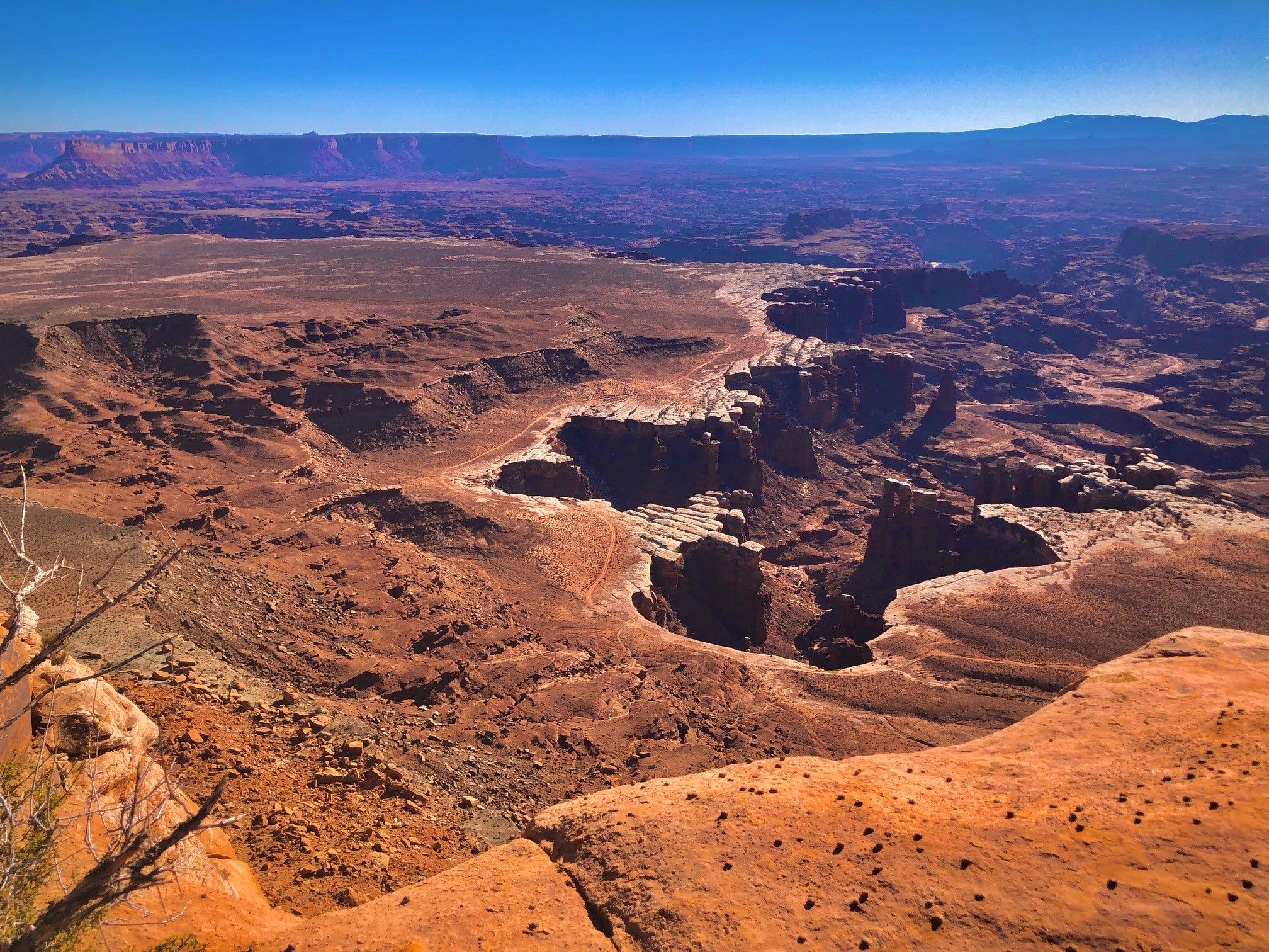
Canyonlands is one of the most remote, desolate national parks in the U.S. covering over 330,000 acres of dramatic desert in southeastern Utah. Its sandstone walls were carved out by the Colorado River and its tributaries much like Grand Canyon, eroded with time leaving behind an Island in the Sky, a flat-topped mesa of panoramic outlooks and miles of maze-like canyons. It’s a red rock paradise of sweeping, jaw-dropping views, wind-swept rocks and plateaus where intersecting rivers have created a geological gold mine. A visit to Canyonlands is like coming to the end of the road and stepping into a foreign land - completely unworldly, wild and vast.
KNOW BEFORE YOU GO
Canyonlands is unlike most other national parks in that it is very isolated and extremely vast. It requires more planning than most. This is not to say you can’t do a quick drive through parts of it, but if you really want to spend some time there, you will need to do your research. Below are some important things to know and consider before going.
OPERATING HOURS & PARK PASSES
Canyonlands is open all day every day, 365 days a year.
Entrance fees are subject to change but are currently as follows:
- Private Vehicle - $30
- Motorcycle - $25
- Pedestrian or Bicycle - $15 per person
- Other passes can be used including the Southeast Utah Annual Park Pass, America the Beautiful Pass, Military Pass, Annual 4th Grade Pass, Lifetime or Annual Senior Passes and Lifetime Access Pass
BACKCOUNTRY & OTHER PERMITS
Much of Canyonlands is undeveloped rugged terrain. All overnight trips into its backcountry require permits which may be challenging to obtain during peak seasons (spring and fall). Reservations are not required but are highly recommended as space is limited.
Day use permits are required for White Rim Road, Elephant Hill, Lavender Canyon and Peekaboo/Horse Canyon roads even if you do not plan on staying overnight.
Your reservation is not your permit. You will receive instructions on where to obtain it once your reservation is complete. Permits are NOT valid on mobile devices. You must have a signed, printed copy in your possession at all times.
Permits not reserved in advance may be available on a first-come, first-serve basis at the Visitor Centers.
Reservations can be made through Recreation.gov up to 2 days prior to your visit but it’s recommended you reserve them at least 4 months in advance of the season in which you plan to visit when they first become available. Below is the schedule.
- Spring (March 10 to June 9) - Reservations open November 10
- Summer (June 10 to September 9) - Reservations open February 10
- Fall (September 10 to December 9) - Reservations open May 10
- Winter (December 10 to March 9) - Reservations open August 10
TEMPERATURES
Canyonlands is considered a high desert meaning temperatures drop dramatically from day to night, as much as 40° F in a single day during all times of year. Be sure to check the weather before leaving home.
Winters can be extremely cold with temperatures rarely reaching over 50° F in the day and often dropping near zero at night. Snow is rare and quite beautiful but be warned, even a light snow can close trails and make roads impassable. When traveling in winter, always check road conditions in advance.
Summers can reach scorching temperatures of over 100° F with little shade and often see monsoons with flash floods. If you plan to visit in the summer, bring plenty of water, do not engage in extremely strenuous exercise and if rain is predicted, avoid areas like slot canyons and locations prone to flash floods.
Spring and fall are the best times to visit. From April to May and September to October, highs average 60-80° F and lows average 30-50° F.

4 WHEEL DRIVE
Most of Canyonlands is inaccessible without a high clearance, low range, four-wheel drive vehicle. Many roads are considered extremely technical to navigate and may experience flooding, snow, ice, deep sand, ledges and rock falls. Road conditions can change quickly and unexpectedly. Back country roads with obstructions and hazards may take maintenance hours if not days to clear. Often times, chains and winches become necessary.
Roads requiring 4WD include: Elephant Hill, Salt Creek, Horse Creek, Davis Canyon, Lavender Canyon, Colorado Overlook, and the White Rim.
WATER
Water is an extremely scarce resource within the boundaries of the park. Although water is available at the Island in the Sky and Needles Visitor Centers, there is no water available elsewhere, not even at the Ranger Stations. Canyonlands is a dry desolate place and extremely hot in summer when temperatures easily reach over 100° F so be prepared by bringing plenty of water with you.
WHERE TO STAY
Campgrounds Inside the Park
There are 2 campgrounds inside Canyonlands including the following:
- Island in the Sky (Willow Flat) Campground – 12 individual sites. First come, first serve. Open year round near the spectacular Green River Overlook. Toilets, picnic tables, fire rings. No water.
- The Needles Campground – 26 individual sites and 3 group sites. You can reserve some sites in spring and fall. Other times of year, they are first come, first serve. Group sites can be reserved mid-March to mid-November. Toilets, picnic tables, fire rings.
Highway 211 Campgrounds – Creek Pasture Campground, Hamburger Rock Campground, Superbowl Campground (including group sites).
Highway 128 Campgrounds – Goose Island Campground, Grandstaff Campground, Drinks Canyon Campground, Hal Canyon Campground, Oak Grove Campground, Big Bend Campground, Upper Big Bend Campground, Upper Onion Creek Campground, Lower Onion Campground.
BLM Campgrounds - There are quite a few BLM campgrounds in the vicinity that do not require fees or reservations.
Backcountry Camping – There is extensive backcountry camping throughout Canyonlands that can be used for backpacking, 4-wheel drives, boating or bicycling. There are literally hundreds of miles of hiking trails with designated backcountry campsites. However, you will need a permit for all overnight trips.
Dead Horse State Park - There are several campgrounds at neighboring Dead Horse State Park including Kayenta Campground, Wingate Campground and the Moenkopi Yurts.
Hotels and Rentals - The closest cities to Canyonlands NP with lodging are Moab and Monticello. Both offer numerous hotels, motels, B&Bs and vacation rentals.
REGIONS OF THE PARK
Canyonlands is Utah’s largest national park. It’s so vast that it is divided into distinct districts - Island in the Sky, The Needles, The Maze, Horseshoe Canyon Unit and the rivers that divide them. It literally takes hours traveling between districts so unless you have unlimited time, consider focusing on one district. There are no roads linking the districts together despite their close proximity as a crow flies. It can take 2-6 hours by car to travel between them and there are very limited areas for river crossing.
- ISLAND IN THE SKY
Island in the Sky mesa sits atop 1,000-foot-tall sandstone cliffs overlooking the valley below. There are numerous scenic outlooks along the island, each offering unique perspectives of the picturesque canyons carved out below.
This is the most accessible area of the park and the closest to Moab. Most of it is accessible without 4-wheel drive including paved scenic roads with pull outs. It’s a perfect spot for a day trip and short hikes if you have limited time.
Island in the Sky Visitor Center and Natural History Association bookstore offers exhibits, publications, park information and an orientation video. You can also pick up permits here for the backcountry. This is one of the few spots that has water.
Things to Do
Grand View Point Overlook – This overlook sits at the end of a mile-long sandstone staircase offering panoramic views of red rock spires against azure skies. It sits at the southernmost point of the island with sweeping views of distant mountains, basins and canyons as well as White Rim Road. From the Visitor Center, drive south 12 miles to the end of the road. From the parking lot, you can walk along the 100-yard trail to the first viewpoint for an easy hike. From there, an unpaved trail takes you out another mile down to the cliff’s edge to a second viewpoint. There are ranger led hikes here from spring to fall where you can learn about the park’s geology.
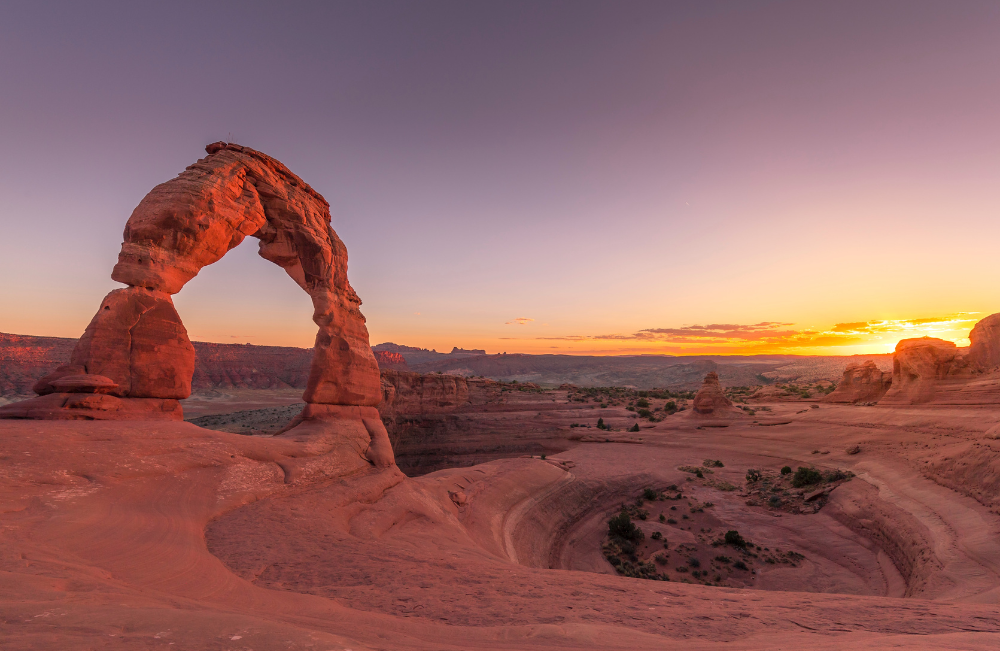
Mesa Arch – An arch that sits right on the edge of a 500-foot cliff with views of the La Sal Mountains and the vast canyon below. This is a great spot to visit at dawn when the sun rises on the horizon behind the arch lighting up the red sandstone in golden tones. The parking lot for Mesa Arch Trail is 6.3 miles south of the Island in the Sky Visitor Center, before Upheaval Dome Road, and fills up very quickly especially at sunrise.
Shafer Trail – An incredible unpaved backcountry road that will leave you in awe with opportunities to see wildlife. The turn off provides a great view of the iconic route as it winds 1,500 feet down along colorful sandstone walls and a massive cliff. However, if you want to travel past this point, you will need a 4WD and low range gear (4LO) for this challenging, treacherous route. It’s also a great spot for mountain bike riding. The 19.6-mile road starts 0.9 miles past the Visitor Center and is moderately trafficked with a 15-mph speed limit. Seatbelts are mandatory and uphill traffic has the right of way.
- THE NEEDLES
The Needles is an area of beautiful backcountry that requires a 4-wheel drive or a boat to access. Hiking in this District is more strenuous than other areas of the park and it is quite remote. It is renowned for its incredible pinnacles and pictographs and is great for backpacking.
Things to Do:
Lavender Canyon – A canyon accessible from a road that follows the canyon bottom through deep sand, deep water and quicksand. If you have the vehicle to navigate its hazards, this canyon is worth exploring as there are a wealth of arches and archaeological sites here, some of which can be seen right off the road. The route is usually too sandy for mountain bikes and includes two major creek crossings with steep banks. A backcountry permit is required even for day use. Interestingly enough, you will find no lavender fields here despite its name.
Elephant Hill Trail – This road is one of the most technical four-wheel drive roads in all of Utah- full of steep grades, loose gravel, stair-step drop offs and hairpin turns making it quite tricky to maneuver. The trail is about 14.5 miles long. The maximum vehicle length allowed, including racks, is 21 feet and 4WD is mandatory. This area gets very hot especially in summer and there is no water at any of the campsites. A backcountry permit is required even for day use.
- THE MAZE
The Maze is an extremely isolated area of the park to the west of the Green River. It is a haven for remote backpacking, strenuous hiking and off roading. It is the least accessible district of Canyonlands and receives the fewest visitors.
The Maze itself is 30 square miles of sheer 600-foot walled canyons that wind about, twisting and dividing back upon themselves that can only be explored by foot. This slew of interwoven canyons often lead to dead ends referred to as a “30-mile puzzle in sandstone.” Like many areas of Canyonlands, GPS often leads one astray so be sure to have a topographical map of the area before venturing here. It can literally take rescuers up to 3 days to reach hikers in an emergency making it not for the faint of heart or ill-prepared, amateur hikers.
Things to Do:
Maze Overlook Trail - A very remote 8-mile, moderately trafficked trail of massive sandstone fins, ruby red canyons with views of the Green and Colorado Rivers converging and incredible petroglyphs. It requires a 6-hour 4WD journey just to reach the trailhead which then takes you along steep exposed rocks and pour-offs. Basic climbing maneuvers, scrambling and rope to navigate are necessary when visiting. Cairns are not always reliable, often times not easily marking the trail, and many spots look alike. Be sure to bring a topographical map and plenty of water which is extremely scarce here.
- HORSESHOE CANYON
Horseshoe Canyon is best known for its significant archaic rock art, probably some of the most intricate, well-preserved designs in all of North America. Two-wheel drive vehicles can usually make it to Horseshoe Canyon but do not rely on GPS. Maps are a necessity.
Things to Do:
Great Gallery - The Great Gallery is the best known and most spectacular panel of both Barrier Canyon style pictographs and petroglyphs in Horseshoe Canyon. At over 200 feet long, the extensive panel is extremely well-preserved containing life-size figures with intricate designs believed to be 1,500-4,000 years old. The hike is approximately 7 miles long and accessible year-round. There is a steep descent of almost 800 feet at the beginning of the trail so be prepared to hike back up it at the end. There is camping nearby at the west rim trailhead on BLM land but camping here within the park boundary is prohibited.
- THE RIVERS OF CANYONLANDS
The Colorado and Green Rivers wind through the heart of Canyonlands, often hidden from view by the complex contours of the unique landscape and not easily accessible. To launch on the Colorado from here, boaters can use the Potash or Moab ramps. To launch on the Green River, boaters can use Green River State Park, Ruby Ranch or Mineral Bottom ramps. There is no vehicle access near the Confluence or in Cataract Canyon. There are also several river rafting outfitters that operate expeditions here.
Leave a comment
This site is protected by hCaptcha and the hCaptcha Privacy Policy and Terms of Service apply.